Introduction to Collection of Prints of Famous Places in the Sixty+ Provinces
Utagawa Hiroshige’s Collection of Prints of Famous Places in the Sixty+ Provinces (1853–1856) features a woodblock print of a famous place in each of the 68 provinces of old Japan, plus a print of Edo, the largest city.
The prints are organized by traditional regions known a Goki-shichidō. “Goki” (short for “Gokinai” or Five Core Provinces) includes provinces around the ancient capitals of Nara and Kyōto; “Shichidō” (Seven Roads) refers to seven roads (land and sea routes) connecting seven groups of contiguous provinces outside the capital region. The seven traditional regions were located on the three islands of Honshū, Shikoku, and Kyūshū, before Hokkaidõ and Okinawa became part of Japan in the nineteenth century.

The pages below are organized by the eight traditional regions of Japan, starting with the central region of Gokinai.
1. Gokinai: Five Core Provinces (Prints 1–5); 2a. Tōkaidō: Eastern Sea Road, Iga to Izu (Prints 6–14); 2b. Tōkaidō: Eastern Sea Road, Sagami to Hitachi (Prints 15–21); 3. Tōsandō: Eastern Mountain Road (Prints 22–29); 4. Hokurikudō: North Coast Road (Prints 30–36); 5. Sanindō: North-Side-of-the-Mountains Road (Prints 37–44); 6. Sanyōdō: South-Side-of-the-Mountains Road (Prints 45–52); 7. Nankaidō: Southern Sea Road (Prints 53–58); 8. Saikaidō: Western Sea Road (Prints 59–69)
Famous Places of Gokinai (Five Core Provinces), Prints 1 – 5
Gokinai (五畿内, Five Core Provinces) consisted of five provinces around the ancient capital of Kyōto, in Yamashiro Province (Kyōto Prefecture today). Prints 1 to 5 in Collection of Prints of Famous Places in the Sixty+ Provinces feature famous places in provinces of Gokinai.

The emperor once ruled the five provinces of Gokinai directly. The first capital, from 538–710, was Asuka, in Yamato Province (Nara Prefecture today). Nara, in Yamato Province, served as capital from 710–794. For short periods, Naniwa, in Settsu Province (Ōsaka Prefecture) also served as capital. Kyōto became the capital in 794 and remained so until 1869, when the emperor and capital were moved east to Tōkyō (“Eastern Capital”).
Note: The numbers on the map above mark the general locations of the famous places in the sixteen provinces of Gokinai. (The modern prefecture equivalents of the old provinces are in parentheses in the list below.) For the location of the sites of the famous places on a Google Map, see “Hiroshige’s “Famous Places in the 60+ Provinces.”
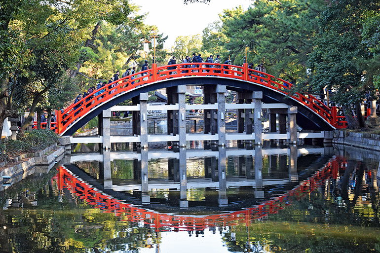
Print 1. Yamashiro: Togetsu (Moon-Crossing) Bridge, Arashiyama
Yamashiro Province (southern Kyōto Prefecture) was the location of Kyōto, the ancient capital. Arashiyama (Mt. Arashi), on the Katsura River, is a district on city’s western side.
Hiroshige’s print depicts Togetsu (Moon-Crossing) Bridge over the Katsura River below a waterfall on Mt. Arashi. In the middle and back ground, sakura trees bloom on the west bank of the river.
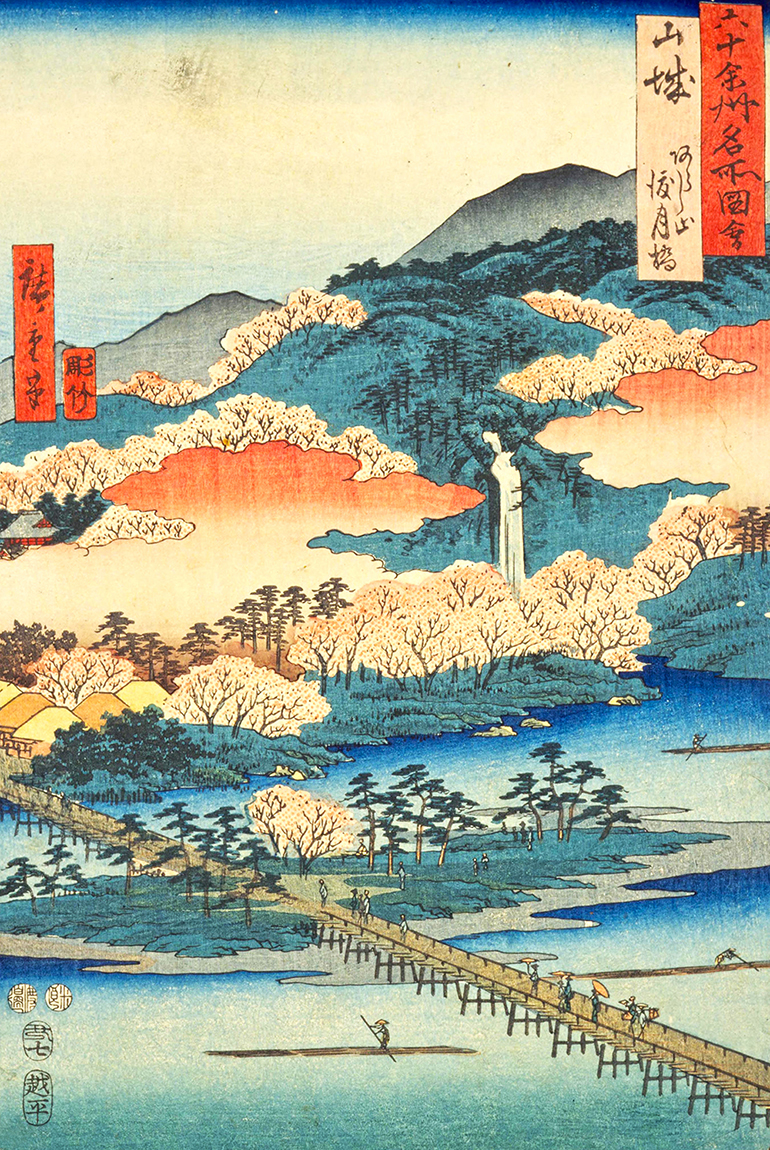
Togetsu Bridge is a popular tourist spot in western Kyōto today. The first bridge at the location was built over a thousand years ago; the current bridge dates from 1934.
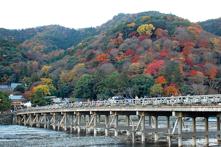
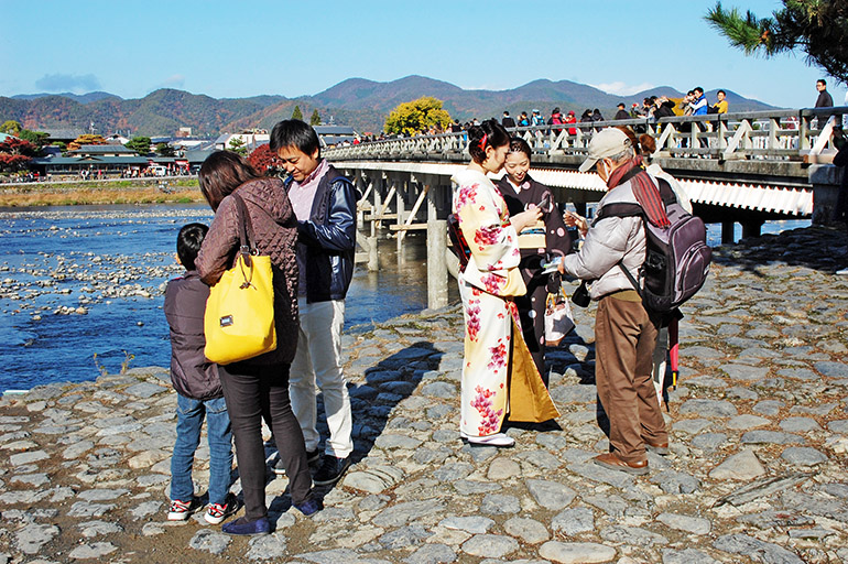
See “ Touring Kyōto: Western Kyōto City; Northwest to the Tango Peninsula” for photos of other famous places in western Kyōto City and northwestern Kyōto Prefecture.
Print 2. Yamato: Tatsuta River and Mountain
South of Yamashiro Province was Yamato Province (Nara Prefecture), the location of the city of Nara, which served as the nation’s capital from 710 to 794.
Hiroshige’s print features the Tatsuta River in autumn, with Mt. Tatsuta above the mist in the background. The river was famous for its autumn beauty because of praise in poems like the following, from the twelfth-century anthology One Hundred Poets, One Poem Each (No. 69): “scarlet leaves blown by a storm on Mt. Mimuro weave a brocade on the Tatsuta River.”
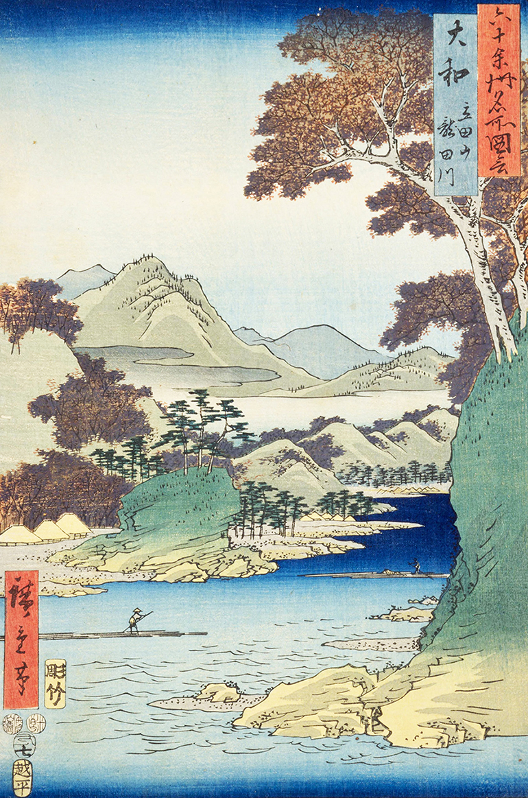
Along the Tatsuta River today, a park offers walking paths.
For photos of other famous places in Nara Prefecture, see “Touring Northern Nara” and “Touring Southern Nara.”
Print 3. Kawachi: Mt. Otoko in Hirakata
West of Yamato Province was Kawachi Province (Eastern Ōsaka Prefecture), the location of Naniwa (Ōsaka City today), on Ōsaka Bay.
Hiroshige’s print depicts the Yodo River flowing between the villages of Hirakata (on the right in the print) and Takatsuki (on the left). Boats traveled up the river from Ōsaka to Fushimi in southern Kyōto. A station at Hirakata monitored boat traffic to the old capital.
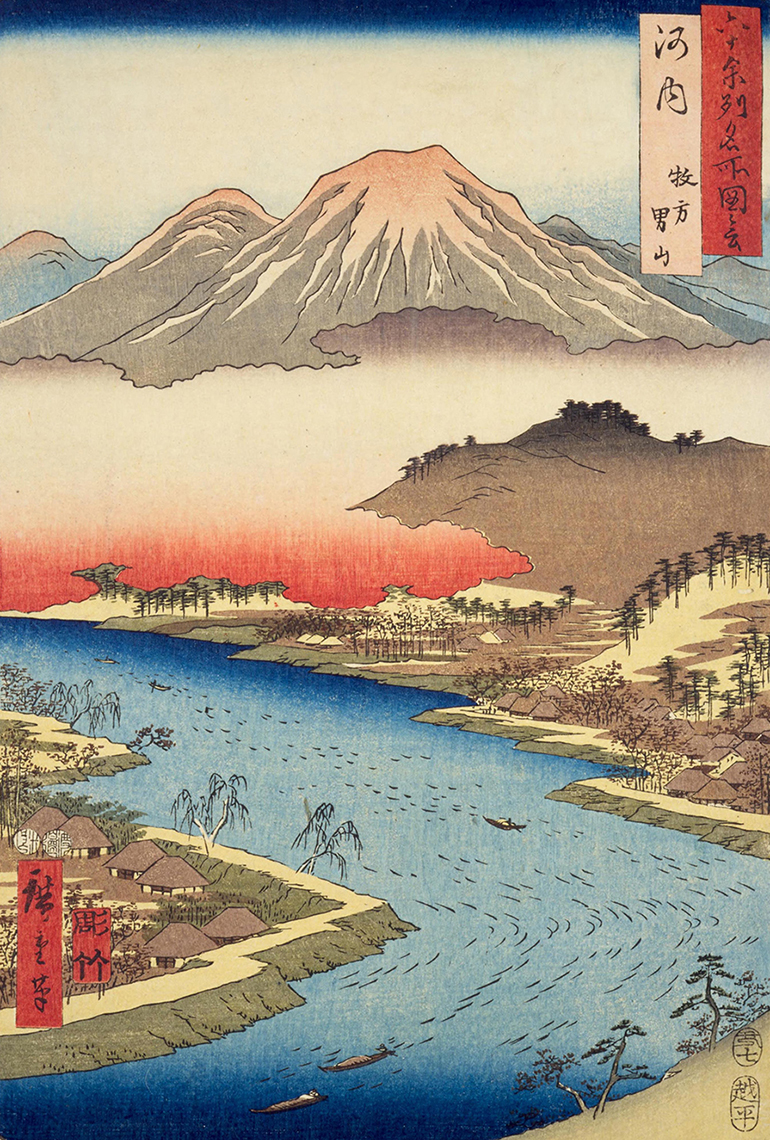
According to Marije Jansen (Hiroshige’s journey in the 60-odd provinces), the mountain rising above the clouds at the center of the pring is Mt. Otoko, which was famous as the site of Iwashimizu Hachiman Imperial Shrine, dedicated to Hachiman, the tutelary deity of the samurai class. The shrine was built in 859 to protect the southern approach to Kyōto. Jansen adds that the mountains to the left Mt. Otoko include “the summit of Mt. Hiei,” above the eastern side of Kyōto; the mountains on the right are “the peaks of Mt. Yokawa and Hira.”
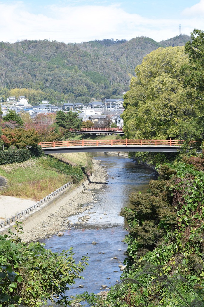
Hiroshige greatly exaggerated the size of Mt. Otoko (due to the vertical composition of the print?) Mt. Otoko is much smaller, more a hill than a mountain (468 feet, 142.5 meters high; see the photo below).
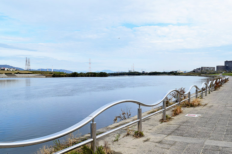
The Yodo River is the longest river in Ōsaka Prefecture. It’s called the Seta River when it flows southwest from its source, Lake Biwa; it becomes the Uji River, as it goes past the town of Uji. Just northwest of Mt. Otoko, in Yawata, the Uji River is joined by the Katsura River from Arashiyama in Kyōto; and the Kizu River, which flows west from Mie Prefecture. When the three rivers join together, the river is called the Yodo. From the confluence of the three rivers at Mt.Otoko, the Yodo flows past Hirakata and Takatsuki and empties into Ōsaka Bay.
Atop Mt. Otoko in Yawata is Iwashimizu Hachiman Imperial Shrine.
For photos of other famous places in Ōsaka Prefecture, see “Touring Ōsaka.”
Print 4. Izumi: Takashi Beach
West of Kawachi Province was Izumi Province (Southwestern Ōsaka Prefecture) on Ōsaka Bay.
Hiroshige’s print presents a bird‘s eye view of the beach at Takashi (written Takaishi on maps today), with Takashi Shrine in the foreground. The beach, town, and Ōsaka Bay fill the middle ground, with the coast of Ōsaka Bay extending from the right to the horizon. Awaji Island appears on the horizon on the left.
In an ancient love poem, an 11th century lady-in-waiting alludes to the waves of Takashi Beach as a metaphor for a suitor’s words of persuasion: “I hear the sound of waves at Takashi Beach, but avoid them, not wanting my sleeves to become wet with tears” (One Hundred Poets, One Poem Each, No. 72).
Takashi Shrine was founded circa 650 A.D. Seafarers and fishermen worshiped at the shrine, which was dedicated to the deity Sukuna-bikona (a nation-building god). Amaterasu (the sun goddess and ancestress of the Imperial family) and Kumano Gongen (a buddha manifested in a Shintō god) are also worshiped at the shrine.
Takaishi Shrine is on Route 204, next to Takashinohama (Takashi Beach) Station.

Takaishi Shrine is located just south of Hamadera Park.
Offshore of the park is an industrial area built on landfill, with a channel between the park and the landfill.
For photos of other famous places in Ōsaka Prefecture, see “Touring Ōsaka.”
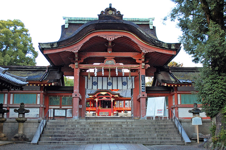
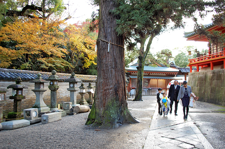
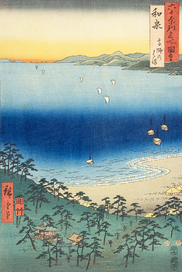
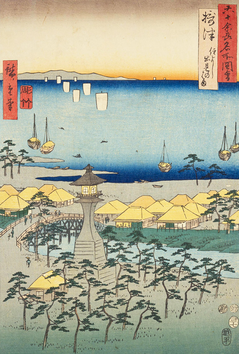
Print 5. Settsu: Demi Beach
North of Izumi Province and west of Yamashiro, on the shore of northern Ōsaka Bay, was Settsu Province (Northwestern Ōsaka and Southeastern Hyōgo prefectures). Demi Beach was on the coast of Settsu near Sumiyoshi, a shrine dedicated to three gods of the sea and also the legendary Empress Jingū. The shrine is believed to be one of the oldest in Japan.
Hiroshige’s print features a lantern tower built near Sumiyoshi Shrine during the Edo Period as an aid to navigation along the coast. Beyond the lantern tower is a bridge to the teahouses along Demi Beach. Beyond the beach, Ōsaka Bay extends out to the horizon, where Awaji Island appears on the left.
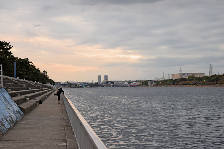
Today, the shrine at Demi is known as Sumiyoshi Grand Shrine (Taisha). Landfill has extended the coast 2-3 miles to the west of the shrine and the area has been transformed by urban development. In the first decade of the twentieth century, the lantern tower near the shrine was on the bank of a waterway, with a bridge nearby.
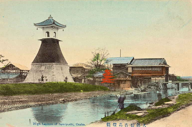
After World War II, the tower was removed in order to build a roadway on landfill. The tower was reconstructed in 1974 about a third of mile west the Sumiyoshi Grand Shrine and serves as a museum today.
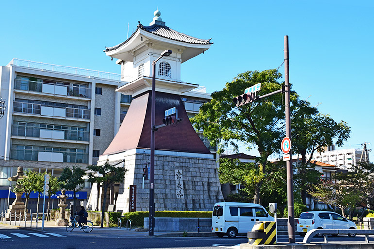
Near the entrance to the shrine is Taiko Bridge, which resembles the arched bridge in Hiroshige’s print. Crossing the bridge at the start of the year is believed to bring good fortune for the year.
For more photos of Sumiyoshi Grand Shrine and other famous places in Ōsaka Prefecture, see “Touring Ōsaka.”

End of Part 1 of 8
Hiroshige’s Famous Places in the 60+ Provinces—Table of Contents
Famous Places in the 60+ Provinces has nine pages (two pages for the Tōkaidō Region and one page for each of the other seven traditional regions of Japan).
- 1. Introduction and Gokinai: Five Core Provinces (Prints 1–5)
- 2a. Tōkaidō: Eastern Sea Road, Iga to Izu (Prints 6–14)
- 2b. Tōkaidō: Eastern Sea Road, Sagami to Hitachi (Prints 15–21)
- 3. Tōsandō: Eastern Mountain Road (Prints 22–29)
- 4. Hokurikudō: North Coast Road (Prints 30–36)
- 5. Sanin-dō: North-Side-of-the-Mountains Road (Prints 37–44)
- 6. Sanyōdō: South-Side-of-the-Mountains Road (Prints 45–52)
- 7. Nankaidō: Southern Sea Road (Prints 53–58)
- 8. Saikaidō: Western Sea Road (Prints 59–69)
- Wikipedia: Hiroshige’s Collection of Prints of Famous Places in the Sixty+ Provinces
- Google Maps: Location of the sites of the famous places, see “Hiroshige’s Famous Places in the 60+ Provinces”
Edo Roads
- Gokaidō: Five Main Roads (Background on roads in Japan during Edo Period, 1603–1868)
- Hiroshige’s Fifty-three Stations of the Tōkaidō (1833–1834; prints and photos of the main road between Edo and Kyōto)
- Hiroshige’s Sixty-nine Stations of the Kisōkaido (1833–1834; prints and photos of the Nakasendō, aka Kisokaidō, the mountain road between Edo and Kyōto)
- Bashō’s Narrow Roads to the Deep North (1689)
- Bashō’s “Sarashina Travel Journal” (1688)

Pacific Journeys: Home and Away
FAMILY AND HOME ||| TRAVELS IN THE PACIFIC ||| ROAD TRIPS IN JAPAN ||| EDO ROADS
